History of Kirkby:
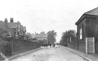
Here you'll find a guided tour of Kirkby. I've also included a few pictures of Kirkby from the good old days. This town trail of Kirkby starts at the Council Offices in Cherryfield Drive. These offices were built in the late 1960s on the site of Kirkby Hall Farm which was one of the largest and oldest farms in the area. The actual farmhouse is now the site of Kirkby Swimming Pool and across the road from the Pool is St Chad's Church. The present church was built in 1871, replacing an earlier chapel dating from 1766. The Church interior includes a Norman baptismal font dating from the 12th century and some attractive stained glass windows.Continuing up Kirkby Row, one of the oldest highways in Kirkby, we come on our right hand side to an old sandstone dwelling, Sefton Cottage. The use of sandstone is a good indication of an old Kirkby building. Further along stood the Post Continuing along Glovers Brow, we pass the Railway Hotel, part of which used to be a coal depot. There are then four houses, "Inglehurst", "Stanley Villa", "Pemberton Villa" and "Homer Lea". Further on is another Public House, the Carter's Arms We now come to the junction with North Park Road and Mill Lane, some of the properties in North Park Road date back to the 1860s. During the war some 200 houses were built on the Park Estate as accommodation for workers at the Royal Ordnance Factory. Office, the site is opposite Holy Angels School. At the top of Kirkby row is the junction with Whitefield Drive (formerly Shaw Lane), and Glovers Brow. Turning into Glovers Brow we pass an old cottage before crossing the bridge over the railway line. The present modern station building is to the left of the bridge, the original station and ticket office being on the right hand side. We now turn right into Mill Lane passing as we do so an old building known as Woods Garage and until fairly recently the last remaining smithy, this view has barely changed since the early 1900s. Mill Lane as its name would suggest was the site of a cornmill. The watermill stood until the 1950s and the mill pond and dam, restored in the 1960s, can still be seen. Mill Lane now becomes Boyes Brow and this then joins the junction of Bank Lane. Turning right into County Road we pass over the railway bridge. To our left, between the railway line and Ruffwood School, used to stand the waterworks with its distinctive water tower, said to have been modelled on towers at Warwick Castle. This building was demolished in the 1960s but gave its name to the Tower Hill area of the town. County Road was originally called School Lane and the old Church of England school was situated on the junction with Old Rough Lane. This school, pulled down in the early 1970s, was erected in 1806, and until the 1950s was the only school in Kirkby. From County Road we turn right into Park Brow Drive. Until the 1880s, at the corner of Park Brow Drive and Bullens Road, stood a cross, locally known as the Weeping Stone. In days past local Catholics were not allowed burial in Kirkby and the procession would halt here on the way to Gillmoss. The cross, which lost its cross-piece in the 19th century, now stands, as an obelisk, in St. Chad's Park. Continue to the end of Park Brow Drive and then turn right into Broad Lane, another of the old byways, and then right again into Bewley Drive, formerly called Cat Tail Lane.
|
Historical pictures of Kirkby
 Date of Photo: c1930s. Date of Photo: c1930s.View of Kirkby Mill, which was demolished in the 1950s. One of the earliest references to the mill occurs with the death of Sir Ralph de Beetham in 1254. In 1323, Henry de Bootle of Melling appears to have had trouble with flooding. His lands suffered as a result of the erection of a mill dam in Kirkby. At a court hearing the dam was ordered to be taken down. In 1665, when Thomas Gerard sold his lands in Kirkby they included a mill. The mill continued it's existence down the centuries. It is clearly marked on the Manorial Map of Kirkby, dated 1769. A mill and mill pond are marked to the north of the present Mill Lane. The 1891 map shows Kirkby Mill. It appears to have created a mill pond of 1.337 acres. The outlet to the pond discharged southwards via Mill Brook, passing the church of St. Chad, eventually to drain into the River Alt  The Mill Dam Lake at Kirkby was a popular site for boating and swimming.  View of the Lodge with St Chad's Church in the background taken from the present Kirkby Row and James Holt avenue area. |